


Ellie Lane
Level: Advanced

Location: Ramona
Distance: 8.2 miles out and back
Where to Start: Park at the small lot on Ellie Lane, off of Highway 67.
Secret’s Out: Iron Mountain is packed on weekends, but the nearby Ellie Lane offers a lesser-traveled—though no less challenging—run. The trail, bordered by thick chaparral, winds up and down technical trails (watch your feet!) and eventually joins with the main trail up Iron Mountain.
Insider Tip: Be on the lookout for the pair of nesting golden eagles once you reach the highest point of Ellie Lane.
Sweetwater Interpretive Loop
Level: Beginner
Location: El Cajon
Distance: 9 miles for the loop
Where to Start: Just south of the McGrath Family YMCA along Highway 94, park your car in the spur off the start of Singer Lane. The trail begins on the other side of the steel bridge.
Secret’s Out: This mostly flat trail is hot and exposed but provides the chance to see the endangered least Bell’s vireo or California gnatcatcher birds as you run by. Continue past the interpretive signs to test your mettle on the rolling hills.
Insider Tip: Snag a photo on the Sweetwater River Bridge, built in 1929.
Santa Margarita River Trail
Level: Beginner
Location: Fallbrook
Distance: 5 miles out and back
Where to Start: At the trailhead off Sandia Creek Road
Secret’s Out: This sandy single-track trail, one of the few un-diverted channels in San Diego county, is lined with wild grape vines and a river.
Insider Tip: Poison oak grows in abundance near the river; stay on the paths to avoid a nasty rash.

6 San Diego Running Trails You Never Knew Existed
Tecolote Canyon in Bay Park
Tecolote Canyon
Level: Beginner (with option for advanced)
Location: Bay Park
Distance: 4–6 miles out and back
Where to Start: Tecolote Nature Center
Secret’s Out: Tecolote Canyon offers a sandy reprieve from the bustle of the I-5. Take the easier path that parallels the Tecolote Canyon Golf Course, or test your climbing legs with the “roller coasters,” a series of very steep hills that will leave you sweating.
Insider Tip: Go in the morning to enjoy cool patches of fog, and watch as birders flock to the area to spot the rare chestnut-breasted mannikin. Plus, earlier mornings mean fewer rattlesnakes!
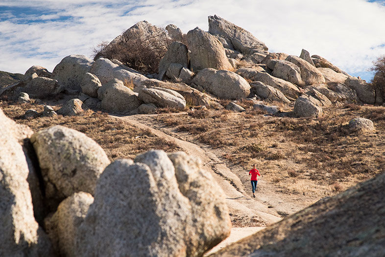
Eagle Rock
Level: Beginner
Location: Warner Springs
Distance: 6.5 miles out and back
Where to Start: Park across the street from the Warner Springs Fire Station, then (carefully!) cross the road. The trail begins at a small gate.
Secret’s Out: Eagle Rock, a formation of boulders that looks exactly like an eagle—no head-tilting and eye-squeezing needed—is the highlight, but the out-and-back trail follows the Pacific Crest Trail. Overhanging oaks shade it the first few miles. By the third, the trail rolls through expansive grasslands.
Insider Tip: Go in winter or spring, when dry fields are replaced by iridescent greens.
Fry-Koegel
Level: Intermediate
Location: Poway
Distance: 2.7 miles out and back
Where to Start: Mount Woodson Golf Club, off of Archie Moore Road
Secret’s Out: A quiet alternative to the hour-long line of those waiting to take their picture on Potato Chip Rock via the Mount Woodson Trail, Fry-Koegel has gently rolling hills that lead you under sycamores and oaks.
Insider Tip: Jog up from the Lake Poway side for a longer (and harder) hike. You’ll see the sign for the new Fry-Koegel trail on your left roughly two miles in.

6 San Diego Running Trails You Never Knew Existed
Eagle Rock in Warner Springs
